The oldest virtual antiquarium in Hungary.
Sós Antikvárium
Designed and made byme4875. engraving/Portrait/Hungarian put into the basket Axmann, Josef: Ferenc József és Erzsébet. (Franz Joseph und Elisabeth).Wien. ca. 1854. .size: 35x31 cm. page: 53x34 cm. price: 255.68 EUROKézzel szÃnezett acélmetszet.
.... Josef Axmann (* 7. März 1793 in Brünn; †9. November 1873 in Salzburg) Osztrák grafikus. www.http://kulturpool.at/. | 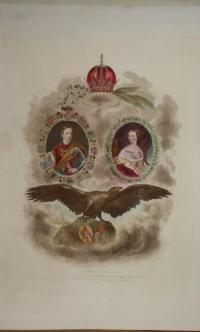 |
te1532. map/The Netherlands put into the basket Mollo, Tranquillo (kiadó): Karte von HOLLAND.Wien. 1817. border colored copper engraving.size: 32x44 cm. page: 37x48 cm. stained outside the picture. price: 68.18 EUROMegjelent: Lehrbuch der Geographie, zeigt das Kaisertum Österreich nach dem Wiener Kongress. | 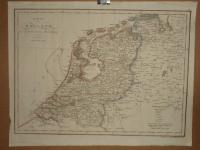 |
ko15563. book/rare books put into the basket Compendio de la Vida de Emerico Tekeli, Cabeça de los Rebeldes y confederado con los Turcos en UngrÃa. Escrito primero en la lengua Aleman y despues traducido Italiano.Madrid. 1684. Mateo De Llanos. 23 p. half cloth binding.size: 20x14 cm. price: 426.14 EUROEnyhén körül vágva. Spanyol nyelvű.
XX. századi félvászon-kötésben. Jó állapotú példány. Hungarica, Apponyi II. 1142. Irodalom: Az ember - kultúrtörténeti és poétikai megközelÃ... | 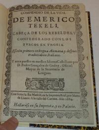 |
