
The oldest virtual antiquarium in Hungary.

Sós Antikvárium
Designed and made byte1433. map/Spain, Portugal put into the basket Charte von Portugal. Nach W. Faden.Weimar. 1801. border colored copper engraving.size: 69x48 cm. page: 76x55 cm. price: 127.84 EURO | 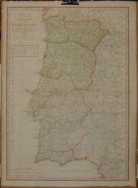 |
me6398. engraving/Ex libris/German put into the basket Orlik, Emil: Ex libris Franz Anderle.1904. .size: 10x9 cm. page: 19x16 cm. stained outside the picture. price: 227.27 EUROAquatint and etching.
Emil Orlik (Czech, 1870 - 1932). | 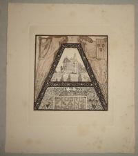 |
ko16766. book/religion, church put into the basket Ókeresztény írók I-XIV. köt.Budapest. 1980-97. Szent István Társulat. 1 p. cloth binding. Hungarian language.size: 9x13 cm. price: 426.14 EURO1,Vanyó László: Az ókeresztény egyház és irodalma
2,Apokrifek 3,Apostoli atyák 4,Euszebiosz egyháztörténete 5,Az ókeresztény kor egyházfegyelme 6,A kappadókiai atyák 7,Vértanúa... | 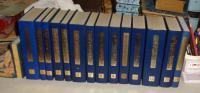 |
