The oldest virtual antiquarium in Hungary.
Sós Antikvárium
Designed and made byte975. map/Hungarian county map put into the basket Gönczy Pál: Lika-Krbava vármegye térképe. Croatia.Budapest. 1894. .size: 24x30 cm. price: 1500 FORINTGönczy Pál (Hajdúszoboszló, 1817. dec. 26. – Karácsond, 1892. jan. 10.):
pedagógus, az MTA l. tagja (1858). 1834-től a debreceni kollégiumban bölcsészetet tanult, 1838-tól tanító, ill.... | 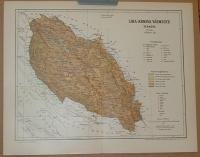 |
te1008. map/Hungarian county map put into the basket Gönczy Pál: Tolna vármegye térképe.Budapest. 1894. .size: 30x24 cm. price: 1500 FORINTGönczy Pál (Hajdúszoboszló, 1817. dec. 26. – Karácsond, 1892. jan. 10.):
pedagógus, az MTA l. tagja (1858). 1834-től a debreceni kollégiumban bölcsészetet tanult, 1838-tól tanító, ill.... | 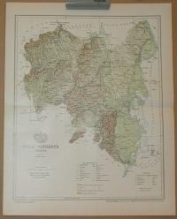 |
te1229. map/America put into the basket Bonne, Rigobert: L'Ancien et le Nouveau Mexique avec la Floride et la Basse Louisiane. Partie Orientale.Paris. ca. 1780. copper engraving.size: 22x33 cm. page: 31x44 cm. price: 45000 FORINTMexikó, Honduras, Nicaragua, Costa Rica. | 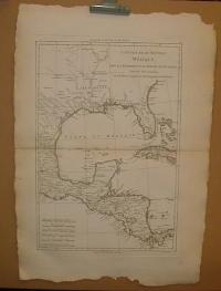 |
te230. map/America put into the basket Meyer: Südlichster Theil von America enthaltend Bolivia, das südliche Brasilien, Paraguay, Chile, La Plata, Cisplatina und Patagonien (South America).Hildburghausen. 1834. border colored steel engraving.size: 22x27 cm. page: 28x33 cm. price: 2800 FORINTstained. | 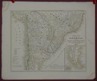 |
te1230. map/America put into the basket Bonne, Rigobert: Isles de Cuba et de la Jamaique.Paris. ca. 1780. copper engraving.size: 22x33 cm. page: 31x44 cm. price: 45000 FORINT | 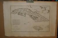 |
te1539. map/United Kingdom put into the basket Mollo, Tranquillo (kiadó): General Carte von Gross Brittannien.Wien. 1817. border colored copper engraving.size: 44x32 cm. page: 48x37 cm. stained outside the picture. price: 40000 FORINTMegjelent: Lehrbuch der Geographie, zeigt das Kaisertum Österreich nach dem Wiener Kongress. | 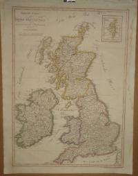 |
te1527. map/Poland put into the basket Mollo, Tranquillo (kiadó): Schleisen ( POLEN).Wien. 1817. border colored copper engraving.size: 31x43 cm. page: 37x48 cm. stained outside the picture. price: 40000 FORINTMegjelent: Lehrbuch der Geographie, zeigt das Kaisertum Österreich nach dem Wiener Kongress. | 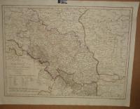 |
te1531. map/The Netherlands put into the basket Mollo, Tranquillo (kiadó): NIEDERLAND.Wien. 1817. border colored copper engraving.size: 43x31 cm. page: 48x37 cm. stained outside the picture. price: 40000 FORINTMegjelent: Lehrbuch der Geographie, zeigt das Kaisertum Österreich nach dem Wiener Kongress
Az alsó szélén szakadás. | 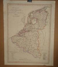 |
te1520. map/America put into the basket Mollo, Tranquillo (kiadó): Charte von West-Indien.Wien. 1817. border colored copper engraving.size: 31x43 cm. page: 37x48 cm. stained outside the picture. price: 40000 FORINTMegjelent: Lehrbuch der Geographie, zeigt das Kaisertum Österreich nach dem Wiener Kongress. | 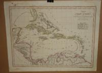 |
te1534. map/Italy put into the basket Mollo, Tranquillo (kiadó): Charte des LOMBARDISCH. VENETIANISCHEN Koenigreichs.Wien. 1817. border colored copper engraving.size: 32x44 cm. page: 37x48 cm. stained outside the picture. price: 40000 FORINTMegjelent: Lehrbuch der Geographie, zeigt das Kaisertum Österreich nach dem Wiener Kongress. | 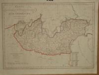 |
te1536. map/Italy put into the basket Mollo, Tranquillo (kiadó): PARMA, PIAZENZA, GUASTALA. MODENA, LUKKA,.Wien. 1817. border colored copper engraving.size: 44x32 cm. page: 49x37 cm. stained outside the picture. price: 40000 FORINTMegjelent: Lehrbuch der Geographie, zeigt das Kaisertum Österreich nach dem Wiener Kongress. | 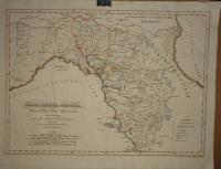 |
te1521. map/China put into the basket Mollo, Tranquillo (kiadó): Chinesischen Reich.Wien. 1817. border colored copper engraving.size: 31x43 cm. page: 37x48 cm. stained outside the picture. price: 45000 FORINTMegjelent: Lehrbuch der Geographie, zeigt das Kaisertum Österreich nach dem Wiener Kongress. | 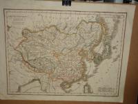 |
te1518. map/Russia put into the basket Mollo, Tranquillo (kiadó): Karte von Russland in Europa.Wien. 1817. border colored copper engraving.size: 43x31 cm. page: 48x37 cm. price: 40000 FORINTMegjelent: Lehrbuch der Geographie, zeigt das Kaisertum Österreich nach dem Wiener Kongress. | 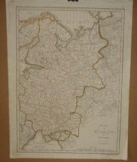 |
te1001. map/Hungarian county map put into the basket Gönczy Pál: Zágráb vármegye térképe.Budapest. 1894. .size: 24x30 cm. price: 1200 FORINTGönczy Pál (Hajdúszoboszló, 1817. dec. 26. – Karácsond, 1892. jan. 10.):
pedagógus, az MTA l. tagja (1858). 1834-től a debreceni kollégiumban bölcsészetet tanult, 1838-tól tanító, ill.... | 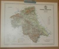 |
te998. map/Hungarian county map put into the basket Gönczy Pál: Varasd vármegye térképe.Budapest. 1894. .size: 24x30 cm. price: 1200 FORINTGönczy Pál (Hajdúszoboszló, 1817. dec. 26. – Karácsond, 1892. jan. 10.):
pedagógus, az MTA l. tagja (1858). 1834-től a debreceni kollégiumban bölcsészetet tanult, 1838-tól tanító, ill.... | 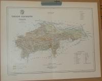 |
te999. map/Hungarian county map put into the basket Gönczy Pál: Verőce vármegye térképe.Budapest. 1894. .size: 24x30 cm. price: 1200 FORINTGönczy Pál (Hajdúszoboszló, 1817. dec. 26. – Karácsond, 1892. jan. 10.):
pedagógus, az MTA l. tagja (1858). 1834-től a debreceni kollégiumban bölcsészetet tanult, 1838-tól tanító, ill.... | 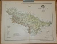 |
te1011. map/Hungarian county map put into the basket Gönczy Pál: Ugocsa vármegye térképe.Budapest. 1894. .size: 30x24 cm. price: 1200 FORINTGönczy Pál (Hajdúszoboszló, 1817. dec. 26. – Karácsond, 1892. jan. 10.):
pedagógus, az MTA l. tagja (1858). 1834-től a debreceni kollégiumban bölcsészetet tanult, 1838-tól tanító, ill.... | 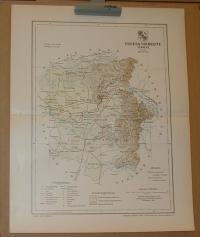 |
te1024. map/Hungarian county map put into the basket Gönczy Pál: Ung vármegye térképe.Budapest. 1894. .size: 30x24 cm. price: 1200 FORINTGönczy Pál (Hajdúszoboszló, 1817. dec. 26. – Karácsond, 1892. jan. 10.):
pedagógus, az MTA l. tagja (1858). 1834-től a debreceni kollégiumban bölcsészetet tanult, 1838-tól tanító, ill.... | 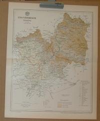 |
te1034. map/Hungarian county map put into the basket Gönczy Pál: Csongrád vármegye térképe.Budapest. 1894. .size: 30x24 cm. price: 1200 FORINTGönczy Pál (Hajdúszoboszló, 1817. dec. 26. – Karácsond, 1892. jan. 10.):
pedagógus, az MTA l. tagja (1858). 1834-től a debreceni kollégiumban bölcsészetet tanult, 1838-tól tanító, ill.... | 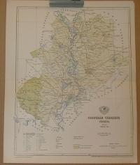 |
te1013. map/Hungarian county map put into the basket Gönczy Pál: Borsod vármegye térképe.Budapest. 1894. .size: 30x24 cm. price: 1200 FORINTGönczy Pál (Hajdúszoboszló, 1817. dec. 26. – Karácsond, 1892. jan. 10.):
pedagógus, az MTA l. tagja (1858). 1834-től a debreceni kollégiumban bölcsészetet tanult, 1838-tól tanító, ill.... | 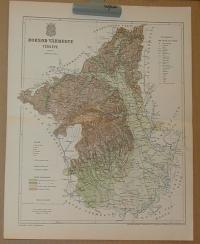 |
