The oldest virtual antiquarium in Hungary.

Sós Antikvárium
Designed and made byte269. map/Germany put into the basket Münster, Sebastian: Germany (Deutschland).Basel. 1558. wood engraving.size: 13x15 cm. page: 31x21 cm. price: 6000 FORINTCosmographia
a képmezőn kívül foltos/marked outside the picture. | 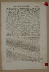 |
te276. map/Germany put into the basket Münster, Sebastian: Germany (Deutschland).Basel. 1558. wood engraving.size: 10x13 cm. page: 31x20 cm. price: 6000 FORINTCosmographia. | 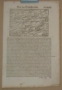 |
te275. map/Germany put into the basket Münster, Sebastian: Germany (Deutschland).Basel. 1558. wood engraving.size: 22x16 cm. page: 31x21 cm. price: 6000 FORINTCosmographia
a képmezőn kívül foltos/marked outside the picture. |  |
te1273. map/Russia put into the basket AA VAN DER PIERRE: LA MOSCOVIE SEPTENTRIONALE, SUIVANT LES NOUVELLES OBSERVATIONS.Leiden. 1714. copper engraving.size: 21x29 cm. page: 26x40 cm. folded. price: 25000 FORINTMap of southern Russia in Europe. | 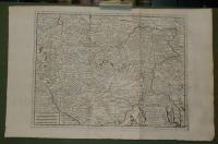 |
te1272. map/Russia put into the basket AA VAN DER PIERRE: LA MOSCOVIE SEPTENTRIONALE, SUIVANT LES NOUVELLES OBSERVATIONS.Leiden. 1714. copper engraving.size: 21x28 cm. page: 26x40 cm. folded. price: 25000 FORINTMap of northern Russia in Europe. | 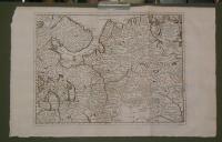 |
te1259. map/France put into the basket Münster: Gallia.Basel. ca.1560. wood engraving.size: 8x14 cm. page: 33x20 cm. stained. price: 4500 FORINT |  |
te1261. map/France put into the basket Münster: Gallia. Engellender und Burgunder miteinander in zwentracht waren/ ist sie in einen schlechten Stand und Wesen gerathen.Basel. ca.1560. wood engraving.size: 12x15 cm. page: 32x20 cm. price: 4500 FORINT |  |
te1339. map/France put into the basket Topographische Karte von Paris und Gegend.Hildburghausen. ca. 1860. steel engraving.size: 22x27 cm. page: 24x30 cm. price: 1800 FORINT | 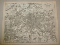 |
te1209. map/Spain, Portugal put into the basket Bonne, Rigobert: Isles Acores.Paris. ca.1780. copper engraving.size: 22x33 cm. page: 32x46 cm. price: 24000 FORINTAzori szigetek. | 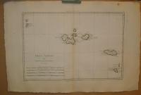 |
te1217. map/Australia, Oceanian put into the basket Bonne, Rigobert: Carte des Isles des Amis.Paris. ca. 1780. copper engraving.size: 22x33 cm. page: 31x44 cm. price: 16000 FORINTTongataboo, Wateeoo. | 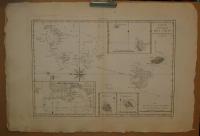 |
te1220. map/Australia, Oceanian put into the basket Bonne, Rigobert: Esquisse de la Baye Dusky, dans la Nouvelle Zeelande.Paris. ca. 1780. copper engraving.size: 22x33 cm. page: 31x44 cm. price: 12000 FORINT | 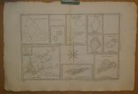 |
te1210. map/Australia, Oceanian put into the basket Bonne, Rigobert: Carte des Isles de la Societé.Paris. ca. 1780. copper engraving.size: 22x33 cm. page: 31x44 cm. price: 24000 FORINTFrancia Polinézia. Társaság szigetek. | 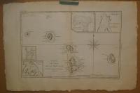 |
te1205. map/Australia, Oceanian put into the basket Bonne, Rigobert: Isles des Nouvelles Hébrides, et celle de la Nouvelle Calédonie. ( France , Vanuatu ).Paris. ca.1780. copper engraving.size: 22x33 cm. page: 32x46 cm. price: 15000 FORINT | 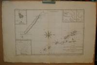 |
te1211. map/America put into the basket Bonne, Rigobert: Les Petites Antilles ou Les Isles Du Vent, avec Celles de Sous Le Vent.Paris. ca. 1780. copper engraving.size: 22x33 cm. page: 31x44 cm. price: 28000 FORINT | 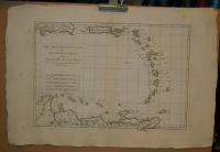 |
te1208. map/America put into the basket Bonne, Rigobert: Isles de la Reine Charlotte.Paris. ca.1780. copper engraving.size: 22x33 cm. page: 32x46 cm. price: 12000 FORINT | 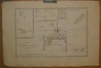 |
te1204. map/Australia, Oceanian put into the basket Bonne, Rigobert: Carte du Gouvernement de Bretagne. Assujettie au ciel et projettee.Paris. ca.1780. copper engraving.size: 22x33 cm. page: 32x46 cm. price: 12000 FORINTPapua New Guinea. | 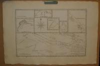 |
te1222. map/Australia, Oceanian put into the basket Bonne, Rigobert: Galles Meridle. ou Cote Orientale de la Nouvelle Hollande.Paris. ca. 1780. copper engraving.size: 22x33 cm. page: 31x44 cm. price: 24000 FORINT | 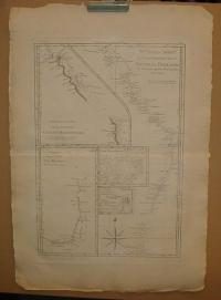 |
te1225. map/Africa put into the basket Bonne, Rigobert: Le Royaume D'Adel: Les Cotes D'Ajan et de Zanguebar.Paris. ca. 1780. copper engraving.size: 22x33 cm. page: 31x44 cm. price: 18000 FORINT | 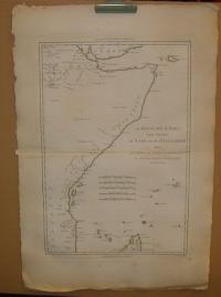 |
te1231. map/America put into the basket Bonne, Rigobert: Isles de St. Domingue et celle de Porto Rico.Paris. ca. 1780. copper engraving.size: 22x33 cm. page: 31x44 cm. price: 36000 FORINTDominica, Puerto Rico. | 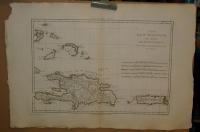 |
te1202. map/America put into the basket Bonne, Rigobert: Nouveau Royaume de GRENADE, Nouvelle ANDALOUSIE et GUYANE.Paris. ca. 1780. copper engraving.size: 22x33 cm. page: 31x46 cm. price: 18000 FORINT | 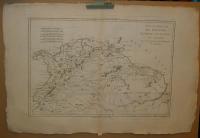 |
te1226. map/America put into the basket Bonne, Rigobert: Pérou et Pays Circonvoisins.Paris. ca. 1780. copper engraving.size: 22x33 cm. page: 31x44 cm. price: 24000 FORINTRepública del Perú. | 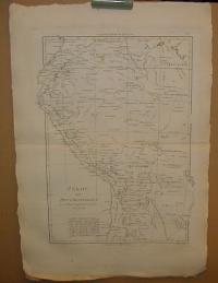 |
te1227. map/America put into the basket Bonne, Rigobert: Bresil et Pays Des Amazones, avec Le Gouvernement De Buenos-Ayres I-II.Paris. ca. 1780. copper engraving.size: 22x33 cm. page: 31x44 cm. price: 25000 FORINTBrasilia. | 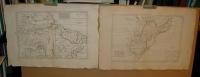 |
te170. map/America put into the basket Bonne, Rigobert: LES ISLES ANTILLES, ET LE GOLFE DU MÉXIQUE.Paris. 1787. copper engraving.size: 21x32 cm. page: 26x38 cm. in green paspartu. intact margin. price: 36000 FORINTJó állapotú. Good condotion.
A jobb felső sarokban a Bermudák. | 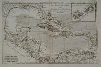 |
te173. map/America put into the basket Bonne, Rigobert: PARTIE MÉRIDIONALE, DE L'ANCIEN MÉXIQUE ( Mexico).Paris. 1787. copper engraving.size: 21x32 cm. page: 26x39 cm. in green paspartu. intact margin. price: 36000 FORINTJó állapotú. Good condition. | 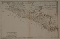 |
te299. map/America put into the basket Bonne, Rigobert: La Guyane Francoise, avec partie de la Guyane Hollandoise: suivant les Opérations et les Cartes récentes des Ingénieurs-Géographes Francois (South America).Paris. 1787. copper engraving.size: 32x21 cm. page: 40x26 cm. price: 12000 FORINT | 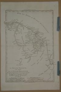 |
te175. map/America put into the basket Bonne, Rigobert: AMÉRIQUE MÉRIDIONALE ( South America).Paris. 1787. copper engraving.size: 32x21 cm. page: 39x26 cm. in green paspartu. minimaly stained outside the picture. price: 28000 FORINT | 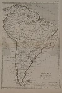 |
te1215. map/America put into the basket Bonne, Rigobert: Isles Maidenland, de Hawkins, et le Detroit de Fakland.Paris. ca. 1780. copper engraving.size: 22x33 cm. page: 31x44 cm. price: 12000 FORINTFalklans szigetek. | 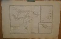 |
te1206. map/Asia put into the basket Bonne, Rigobert: Terre De Kerguelen, Appellee par M. Cook, Isle De La Desolation.Paris. ca.1780. copper engraving.size: 22x33 cm. page: 32x46 cm. price: 12000 FORINT | 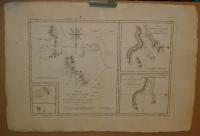 |
te336. map/Indinesia put into the basket Fremin: Skizzirte charte von der Insel Celebes.Prag. 1812. copper engraving.size: 27x18 cm. page: 32x20 cm. price: 9000 FORINT | 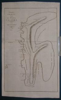 |
te1434. map/China put into the basket Bonne, Rigobert: Empire de la Chine Rme de Corée et Isles du Japon.Paris. 1787. copper engraving.size: 22x34 cm. page: 31x44 cm. price: 36000 FORINTKorea
Japan. | 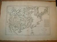 |
te800. map/Israel, Palestine, Judaica put into the basket Lapie: Carte de la Syrie et de L'Egypte anciennes.Paris. 1851. copper engraving.size: 53x37 cm. page: 66x50 cm. intact margin. price: 30000 FORINT | 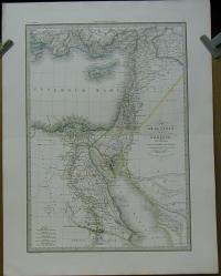 |
te292. map/America put into the basket Bonne, Rigobert: Carte de l'Isle de St. Dominigue (Dominique) une des Grandes Antilles, Colonie Francoise et Espagnole.Paris. 1787. copper engraving.size: 21x32 cm. page: 26x40 cm. minimaly stained. price: 36000 FORINT | 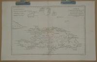 |
te993. map/Hungarian county map put into the basket Gönczy Pál: Modrus-Fiume vármegye térképe.Budapest. 1894. .size: 24x30 cm. price: 1200 FORINTGönczy Pál (Hajdúszoboszló, 1817. dec. 26. – Karácsond, 1892. jan. 10.):
pedagógus, az MTA l. tagja (1858). 1834-től a debreceni kollégiumban bölcsészetet tanult, 1838-tól tanító, ill.... | 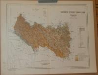 |
te978. map/Hungarian county map put into the basket Gönczy Pál: Alsó-Fehér vármegye térképe.Budapest. 1894. .size: 24x30 cm. price: 1200 FORINTGönczy Pál (Hajdúszoboszló, 1817. dec. 26. – Karácsond, 1892. jan. 10.):
pedagógus, az MTA l. tagja (1858). 1834-től a debreceni kollégiumban bölcsészetet tanult, 1838-tól tanító, ill.... | 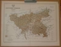 |
te516. map/United Kingdom put into the basket Homann Heredibus: Regnum Magnae Britanniae et Hiberniae Mappa Georgraphica.Nürnberg. 1749. hand colored copper engraving.size: 45x52 cm. page: 51x58 cm. minimaly stained outside the picture. minimal implosion on the margin. price: 60000 FORINT | 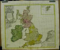 |
te1079. map/Ireland put into the basket Robert De Vaugondy: L'Irlande.Paris. ca. 1760. border colored copper engraving.size: 22x21 cm. page: 29x41 cm. clean, sharp issue. price: 45000 FORINT | 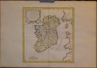 |
te1067. map/Ireland put into the basket Tirion, Isaak: Nieuwe Kaart van Ierland. Ireland.Amsterdam. ca. 1740. hand colored copper engraving.size: 32x25 cm. page: 41x50 cm. minimaly stained outside the picture. folded. price: 70000 FORINT | 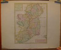 |
te144. map/United Kingdom put into the basket Homann Heredibus: Regionis qvae est circa Londinum (London) specialis repraesentatio geographica.1741. colored copper engraving.size: 50x56 cm. page: 55x65 cm. intact margin. price: 90000 FORINTAt the bottom, there is a very fine London Westminster city view. | 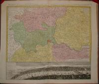 |
te146. map/Scotland put into the basket Johan Baptist Homann: Magnae Britanni, Pars Septentrionalis Regnum Scotiae in Suas Partes et subja centes Insulas divisum Accurata Tabula ex archetypo Vischeriano desumta exhibetur imitatore.1720. colored copper engraving.size: 57x47 cm. page: 63x53 cm. in green paspartu. intact margin. price: 70000 FORINTstained/foltos. | 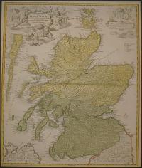 |
te1199. map/Spain, Portugal put into the basket Güssefeld-Homann Heredibus: Regnorum Hispaniae et Portugalliae Tabula generalis.Nürnberg. 1782. hand colored copper engraving.size: 44x55 cm. page: 52x64 cm. stained outside the picture. price: 90000 FORINT | 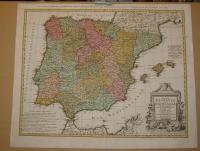 |
te1043. map/Scotland put into the basket Visscher Nicolaum: Exactissima Regni Scotiae Tabula.Amsterdam. 1689. hand colored copper engraving.size: 54x45 cm. page: 61x53 cm. price: 110000 FORINTA fokhálózaton 4 mm-es lyuk van.
Homann Skócia e térkép alapján készült. A hátlapon holland-angol nyelvű helymutató. Irodalom: http://www.geo.ed.ac.uk:81/~rsgs/ifa/gems/MapScot.html. | 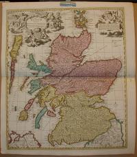 |
te1109. map/Germany put into the basket Homann, Johann Baptist: Exactissima Palatinatus ad Rheinum.Nürnberg. ca. 1730. hand colored copper engraving.size: 47x56 cm. page: 51x60 cm. stained outside the picture. trimmed. price: 45000 FORINT | 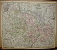 |
te378. map/Germany put into the basket Blaeu: Oldenburg Comitatus.Amsterdam. 1635. copper engraving.size: 38x50 cm. page: 41x54 cm. in blue paspartu. price: 60000 FORINTAttractive map of Oldenburg, also depicting Bremen. From the French edition of Willem Blaeu's atlas "Theatrum". | 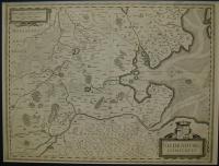 |
te1105. map/Germany put into the basket Lotter: Saxoniae Superioris ....Electoralis Circulus: cum adiacentibus Ducatibus et Provinciis, simulque diligentissime annotatis Postarum Cursus et Stationes.Augsburg. 1745. hand colored copper engraving.size: 47x56 cm. page: 54x68 cm. price: 45000 FORINT | 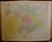 |
te1112. map/Germany put into the basket Sanson Nicolas: PARTIE ORIENTALE DU PALATINAT ET ESLECTORAT DU RHEIN. LES ÉVESCHÉS DE SPIRE, DE WORMES ET LE COMTÉ DE LINANGE.Paris. 1692. border colored copper engraving.size: 39x52 cm. page: 51x65 cm. price: 60000 FORINT | 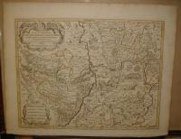 |
te379. map/Germany put into the basket Blaeu: Monasteriensis Episcopatus.Amsterdam. 1635. copper engraving.size: 38x49 cm. page: 42x55 cm. in blue paspartu. minimaly stained outside the picture. price: 70000 FORINTAttractive map of Munster from "Theatrum Orbis Terrarum" or "Novus Atlas". |  |
te139. map/Germany put into the basket Homann, Johann Baptist: Ducatus MEKLENBURGICI Tabula Generalis continens Duc: VANDALIAE et MEKLENBURG Comitatum et Episcopatum.Nürnberg. 1730. hand colored copper engraving.size: 49x57 cm. page: 52x59 cm. intact margin. price: 45000 FORINTDecorative and highly detailed regional map, extending from Holstein and Lubeck in the west to Rugia and Pomerania in the east, and centered on Mecklenburg, Swerinensis, Vandalia, Rostochiense and Sta... | 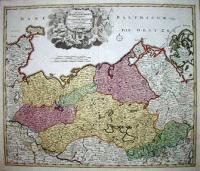 |
te1107. map/Germany put into the basket Homann, Johann Baptist: Ducatus Brunsuicensis in tres fuos Grubenhag.Nürnberg. ca.1730. hand colored copper engraving.size: 48x56 cm. page: 51x59 cm. trimmed. implosion on the margin. price: 25000 FORINT | 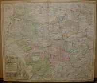 |
te1106. map/Germany put into the basket Homann, Johann Baptist: OSELLAE FLUMINIS TABULA SPECIALIS IN QUA ARCHIEPISCOPATUS ET ELECTORATUS TREVIRENSIS.Nürnberg. ca. 1730. hand colored copper engraving.size: 47x56 cm. page: 51x59 cm. shabby. implosion on the margin. price: 25000 FORINT | 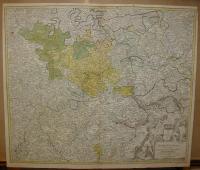 |
te1110. map/Germany put into the basket Homann, Johann Baptist: Ducatus Iuliaci & Bergensis Tabula Geographica, simul Ducatum Cliviae & Meursiae Principatum ... Ducat. Limburgensis.Nürnberg. ca. 1730. hand colored copper engraving.size: 55x46 cm. page: 59x51 cm. damaged. price: 35000 FORINT | 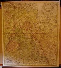 |
