
The biggest map and engraving supply in Hungary.

Sós Antikvárium
Designed and made byte389. map/Hungary Gibson, John: HUNGARY.London. 1752. copper engraving.size: 25x30 cm. page: 34x40 cm. in blue paspartu. intact margin. SOLDSzántai/Gibson1. | 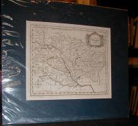 |
te862. map/Hungary Gibson, John: HUNGARY.London. 1758-1798. hand colored copper engraving.size: 6x9 cm. page: 8x11 cm. in blue paspartu. intact margin. SOLDAz egyik legkisebb magyar térkép!
Szántai/Gibson2. | 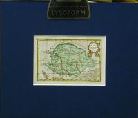 |
te863. map/Hungary Ortelius, Abraham: HUNGARIA.Antwerpen. 1604. hand colored copper engraving.size: 7x11 cm. page: 12x17 cm. in blue paspartu. SOLDHátán német szöveggel.
Szántai Ortelius 443. lap "Epitome" táblázat!. | 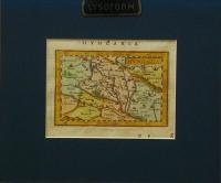 |
te864. map/Hungary Langenes (kiadó): HUNGARIA. Hongrie.1602. hand colored copper engraving.size: 8x12 cm. page: 11x16 cm. in blue paspartu. SOLDHátlapján francia szöveg.
Szántai 330. lap Langenes atlasz kiadásai!. | 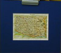 |
te876. map/Hungary Chatelain, Henri Abraham: Nouvelle Carte de la Hongrie, Divisee selon ses Differents Etats, avec une Chronologie de ses Ducs et de ses Rois, dans la'quelle on voit aussi par des Tables alphabetiques, les Archeveschez, Evechez, Universitez, et les Batailles les plus memorables.Amsterdam. 1708. copper engraving.size: 44x48 cm. page: 52x65 cm. in green paspartu. clean issue. intact margin. SOLDSzántai/Chatelain 1. | 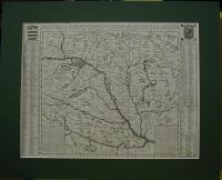 |
te918. map/Hungary Delisle, Guillaume: CARTE PARTICULIERE DE LA HONGRIE DE LA TRANSILVANIE DE LA CROATIE ET DE LA SCLAVONIE / Dressée sur les Observations de M.r le Comte Marsilli et sur plusieurs autres Memoires Par G. Delisle.Paris. 1745. border colored copper engraving.size: 47x56 cm. page: 54x76 cm. in green paspartu. clean, sharp issue. intact margin. SOLDSzántai/Delisle 3b. | 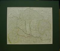 |
te1127. map/Hungary Lipszky Joannes (János): Mappa generalis regni Hungariae partiumque adnexarum Croatiae, Slavoniae et confiniorum militarium magni item principatus Transylvaniae.Pest. 1806. copper engraving.size: 180x225 cm. SOLDRajzolta Godofr. Prixner, rézbe metszette Karacs Ferenc. 12 szelvény vászonra kasírozva, a vármegye határok színesen jelölve. A 9 térkép 49 x 73 cm, a 3 vármegyék adatait mutató lap 27 x ... | 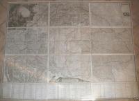 |
te1151. map/Hungary Weigel Christoph: HUNGARIA Cum Adiacentibus Provinciis.Nürnberg. ca. 1716. hand colored copper engraving.size: 39x59 cm. page: 42x63 cm. shabby. SOLDJobb felső sarokban Temesvár ostromkép.
2 lemezről nyomva. Szántai/Weigel/3a. | 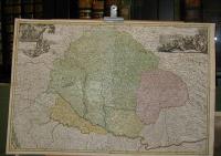 |
te1195. map/Hungary Kitchin (Kitchen), Thomas: A Map of the Kingdom of Hungary.London. 1762. hand colored copper engraving.size: 21x25 cm. page: 29x33 cm. folded. SOLDSzántai/Kitchin 1. | 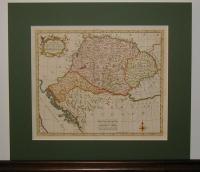 |
te1197. map/Hungary Gibson: HUNGARY.London. 1752. hand colored copper engraving.size: 25x30 cm. page: 33x43 cm. in blue paspartu. SOLDSzántai/Gibson 1. | 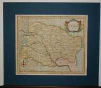 |
te1270. map/Hungary Müller Ignácz ( Müller Ignác): Mappa Geographica novissima Regni Hungariae divisi in suos Comitatus cum Districtibus Jazygum et Cumanorum, Banatus Temesiensis ejusque Districtuum nec non Regnorum Croatiae, Slavoniae, Dalmatiae, Magni Principatus Transsylvaniae, partis Bosniae, Serviae,.Wien. 1769. copper engraving.size: 204x244 cm. clean, sharp issue. mounted on canvas. SOLDKeretre feszítve, keretezésre előkészítve.
Szántai/Müller I. 1a Tiderle Lajos http://lazarus.elte.hu/hun/digkonyv/sc/sc7.htm ----------------------------------------------------------------... | 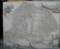 |
te1291. map/Hungary Scherer: Totius Hungariae Deiparae Devotissimae Nova Exhibitio Geographica.München. 1699. copper engraving.size: 21x34 cm. page: 28x41 cm. SOLDVékony arany keretben.
Szántai/Scherer 1. | 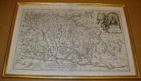 |
te1302. map/Hungary Schenck, Pieter: Nova et accurata tabula sedis belli in regno Hungariae.Amsterdam. 1717. hand colored copper engraving.size: 49x55 cm. page: 53x61 cm. minimal implosion on the margin. SOLDSzántai/Schenk 4. | 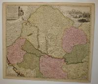 |
te1542. map/Hungary Brion-Desnos: HONGRIE avec les Provinces.Paris. 1766. hand colored copper engraving.size: 23x25 cm. page: 49x66 cm. in green paspartu. SOLD | 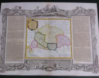 |
